Based on data in OpenStreetMap, here is a list of townlands in Blaris (Castlereagh Upper portion).
Blaris (Castlereagh Upper portion) is in the baronies of Castlereagh Upper.
Blaris (Castlereagh Upper portion) is in the counties of Antrim and Down.
Blaris (Castlereagh Upper portion) is not matched up to Logainm.ie yet.
Map
It is located at 54° 29' 47" N, 6° 2' 1" W.
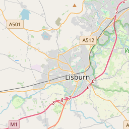
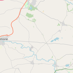

Leaflet | Map data © OpenStreetMap contributors
Area
Blaris (Castlereagh Upper portion) has an area of 12.4 km² / 3,059.2 acres / 4.8 square miles.
Townlands
There are 10 townlands that we know about in Blaris (Castlereagh Upper portion). This represents 100% of all the area in Blaris (Castlereagh Upper portion).
- Baile an tSiáin (see Ballintine (Baile an tSiáin) , Blaris (Castlereagh Upper portion) Civil Parish, Barony of Castlereagh Upper, Co. Down)
- Baile Uí Mhaoláin (see Ballymullan (Baile Uí Mhaoláin) , Blaris (Castlereagh Upper portion) Civil Parish, Barony of Castlereagh Upper, Co. Down)
- Ballintine (Baile an tSiáin) , Blaris (Castlereagh Upper portion) Civil Parish, Barony of Castlereagh Upper, Co. Down 189 A, 1 R, 32 P
- Ballymullan (Baile Uí Mhaoláin) , Blaris (Castlereagh Upper portion) Civil Parish, Barony of Castlereagh Upper, Co. Down 575 A, 1 R, 3 P
- Bláras (see Blaris (Bláras) , Blaris (Castlereagh Upper portion) Civil Parish, Barony of Castlereagh Upper, Co. Down)
- Blaris (Bláras) , Blaris (Castlereagh Upper portion) Civil Parish, Barony of Castlereagh Upper, Co. Down 548 A, 2 R, 35 P
- Dún Eachdach (see Duneight (Dún Eachdach) , Blaris (Castlereagh Upper portion) Civil Parish, Barony of Castlereagh Upper, Co. Down)
- Duneight (Dún Eachdach) , Blaris (Castlereagh Upper portion) Civil Parish, Barony of Castlereagh Upper, Co. Down 412 A, 3 R, 31 P
- Largymore (An Leargaidh Mhór) , Blaris (Castlereagh Upper portion) Civil Parish, Barony of Castlereagh Upper, Co. Down 590 A, 0 R, 31 P
- An Leargaidh Mhór (see Largymore (An Leargaidh Mhór) , Blaris (Castlereagh Upper portion) Civil Parish, Barony of Castlereagh Upper, Co. Down)
- Lios na gCnó (see Lisnoe (Lios na gCnó) , Blaris (Castlereagh Upper portion) Civil Parish, Barony of Castlereagh Upper, Co. Down)
- Lisnoe (Lios na gCnó) , Blaris (Castlereagh Upper portion) Civil Parish, Barony of Castlereagh Upper, Co. Down 152 A, 0 R, 21 P
- Taghnabrick (Teach Bric) , Blaris (Castlereagh Upper portion) Civil Parish, Barony of Castlereagh Upper, Co. Down 354 A, 1 R, 11 P
- Teach Bric (see Taghnabrick (Teach Bric) , Blaris (Castlereagh Upper portion) Civil Parish, Barony of Castlereagh Upper, Co. Down)
- Baile Uí Mhaoláin (see Ballymullan (Baile Uí Mhaoláin) , Blaris (Castlereagh Upper portion) Civil Parish, Barony of Castlereagh Upper, Co. Antrim)
- Ballymullan (Baile Uí Mhaoláin) , Blaris (Castlereagh Upper portion) Civil Parish, Barony of Castlereagh Upper, Co. Antrim 5 A, 3 R, 4 P
- Largymore (An Leargaidh Mhór) , Blaris (Castlereagh Upper portion) Civil Parish, Barony of Castlereagh Upper, Co. Antrim 204 A, 3 R, 21 P
- An Leargaidh Mhór (see Largymore (An Leargaidh Mhór) , Blaris (Castlereagh Upper portion) Civil Parish, Barony of Castlereagh Upper, Co. Antrim)
- Lisnatrunk, Blaris (Castlereagh Upper portion) Civil Parish, Barony of Castlereagh Upper, Co. Antrim 25 A, 1 R, 33 P
Down
Antrim
 OpenStreetMap
Blaris (Castlereagh Upper portion) was added to OpenStreetMap on 2 Aug 2016 by Stephen_Co_Antrim.
- View
- Edit