Based on data in OpenStreetMap, here is a list of townlands in the Electoral Division / ED / District Electoral Division of Castlehaven South.
Castlehaven South ist in der Grafschaft
Castlehaven South is not matched up to Logainm.ie yet.
Karte
Befindet sich bei 51° 30' 15" N, 9° 15' 14" W.

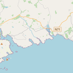


Leaflet | Map data © OpenStreetMap contributors
Fläche
Castlehaven South hat eine Fläche von 19,0 km² / 4,694,1 Acres / 7,3 Quadratmeilen.
Townlands
Uns sind 28 Townlands in bekannt. Das entspricht 95,0% der Fläche in .
- Ardagilla 73 A, 0 R, 0 P
- Ardgehane 184 A, 3 R, 37 P
- Ballyally 198 A, 2 R, 20 P
- Ballyisland 107 A, 0 R, 25 P
- Ballyoughtera 156 A, 2 R, 16 P
- Barryroe 235 A, 2 R, 32 P
- Bawnishall 384 A, 1 R, 24 P
- Bawnlahan 185 A, 1 R, 7 P
- Boolybane 97 A, 3 R, 35 P
- Bullock Island 17 A, 0 R, 27 P
- Crosslea 41 A, 3 R, 36 P
- Curravally 106 A, 0 R, 21 P
- Dooneen 272 A, 0 R, 0 P
- Drishanebeg 336 A, 2 R, 19 P
- Drishane Island 0 A, 3 R, 7 P
- Drishanemore 310 A, 1 R, 27 P
- Drumadoon 139 A, 3 R, 32 P
- Farranconnor 119 A, 0 R, 18 P
- Glannageel 110 A, 2 R, 26 P
- Gokane 190 A, 3 R, 1 P
- Gortacrossig 217 A, 1 R, 8 P
- Gorteenalomane 189 A, 3 R, 20 P
- Lahardane More 231 A, 2 R, 11 P
- Lahernathee 121 A, 1 R, 10 P
- Lickowen 139 A, 3 R, 18 P
- Reendacussane 99 A, 3 R, 33 P
- Scobaun 188 A, 2 R, 34 P
- The Stags 1 A, 2 R, 34 P
 OpenStreetMap
Castlehaven South wurde am 14 Jan 2017 von Teester bei OpenStreetMap erfasst.
- View
- Edit