Based on data in OpenStreetMap, here is a list of townlands in Drumgooland.
Drumgooland ist in den Baronien Iveagh Upper, Lower Half.
Drumgooland ist in den Grafschaften Down.
Drumgooland bei Logainm.ie: Drumgooland.
Karte
Befindet sich bei 54° 17' 42" N, 6° 2' 6" W.
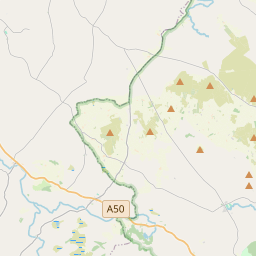
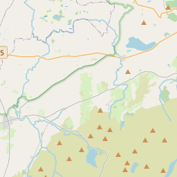

Leaflet | Map data © OpenStreetMap contributors
Fläche
Drumgooland hat eine Fläche von 83,1 km² / 20,529,8 Acres / 32,1 Quadratmeilen.
Townlands
There are 20 townlands that we know about in Drumgooland. This represents 100% of all the area in Drumgooland.
- Bac an Doire (see Backaderry (Bac an Doire) , Gemeinde Drumgooland, Baronie Iveagh Upper, Lower Half, Grafschaft Down)
- Backaderry (Bac an Doire) , Gemeinde Drumgooland, Baronie Iveagh Upper, Lower Half, Grafschaft Down 1743 A, 0 R, 9 P
- Baile an Bhaird (see Ballyward (Baile an Bhaird) , Gemeinde Drumgooland, Baronie Iveagh Upper, Lower Half, Grafschaft Down)
- Baile Dromann (see Ballydrumman (Baile Dromann) , Gemeinde Drumgooland, Baronie Iveagh Upper, Lower Half, Grafschaft Down)
- Baile Mhic Giolla Chiaráin (see Ballymackilreiny (Baile Mhic Giolla Chiaráin) , Gemeinde Drumgooland, Baronie Iveagh Upper, Lower Half, Grafschaft Down)
- Baile Mhig Críocháin (see Ballymagreehan (Baile Mhig Críocháin) , Gemeinde Drumgooland, Baronie Iveagh Upper, Lower Half, Grafschaft Down)
- Baile Mhig Fhionnchaidh (see Ballymaginaghy (Baile Mhig Fhionnchaidh) , Gemeinde Drumgooland, Baronie Iveagh Upper, Lower Half, Grafschaft Down)
- Ballydrumman (Baile Dromann) , Gemeinde Drumgooland, Baronie Iveagh Upper, Lower Half, Grafschaft Down 649 A, 2 R, 27 P
- Ballymackilreiny (Baile Mhic Giolla Chiaráin) , Gemeinde Drumgooland, Baronie Iveagh Upper, Lower Half, Grafschaft Down 991 A, 0 R, 30 P
- Ballymaginaghy (Baile Mhig Fhionnchaidh) , Gemeinde Drumgooland, Baronie Iveagh Upper, Lower Half, Grafschaft Down 1180 A, 2 R, 2 P
- Ballymagreehan (Baile Mhig Críocháin) , Gemeinde Drumgooland, Baronie Iveagh Upper, Lower Half, Grafschaft Down 1237 A, 1 R, 5 P
- Ballyward (Baile an Bhaird) , Gemeinde Drumgooland, Baronie Iveagh Upper, Lower Half, Grafschaft Down 625 A, 1 R, 19 P
- Beann Rátha (see Benraw (Beann Rátha) , Gemeinde Drumgooland, Baronie Iveagh Upper, Lower Half, Grafschaft Down)
- Benraw (Beann Rátha) , Gemeinde Drumgooland, Baronie Iveagh Upper, Lower Half, Grafschaft Down 863 A, 0 R, 11 P
- An Chloch Scoilte (see Cloghskelt (An Chloch Scoilte) , Gemeinde Drumgooland, Baronie Iveagh Upper, Lower Half, Grafschaft Down)
- Clanmaghery (Clár Machaire) , Gemeinde Drumgooland, Baronie Iveagh Upper, Lower Half, Grafschaft Down 362 A, 3 R, 34 P
- Clár Machaire (see Clanmaghery (Clár Machaire) , Gemeinde Drumgooland, Baronie Iveagh Upper, Lower Half, Grafschaft Down)
- Cloghskelt (An Chloch Scoilte) , Gemeinde Drumgooland, Baronie Iveagh Upper, Lower Half, Grafschaft Down 1033 A, 1 R, 15 P
- Dea-choiméad (see Deehommed (Dea-choiméad) , Gemeinde Drumgooland, Baronie Iveagh Upper, Lower Half, Grafschaft Down)
- Deehommed (Dea-choiméad) , Gemeinde Drumgooland, Baronie Iveagh Upper, Lower Half, Grafschaft Down 1526 A, 3 R, 7 P
- Derryneill (Doire Uí Néill) , Gemeinde Drumgooland, Baronie Iveagh Upper, Lower Half, Grafschaft Down 1046 A, 0 R, 29 P
- Doire Uí Néill (see Derryneill (Doire Uí Néill) , Gemeinde Drumgooland, Baronie Iveagh Upper, Lower Half, Grafschaft Down)
- Droim Áth Dúlinne (see Drumadonnell (Droim Áth Dúlinne) , Gemeinde Drumgooland, Baronie Iveagh Upper, Lower Half, Grafschaft Down)
- Droim Lao (see Drumlee (Droim Lao) , Gemeinde Drumgooland, Baronie Iveagh Upper, Lower Half, Grafschaft Down)
- Drumadonnell (Droim Áth Dúlinne) , Gemeinde Drumgooland, Baronie Iveagh Upper, Lower Half, Grafschaft Down 1036 A, 3 R, 28 P
- Drumlee (Droim Lao) , Gemeinde Drumgooland, Baronie Iveagh Upper, Lower Half, Grafschaft Down 540 A, 3 R, 29 P
- Garbhdhoire (see Gargarry (Garbhdhoire) , Gemeinde Drumgooland, Baronie Iveagh Upper, Lower Half, Grafschaft Down)
- Gargarry (Garbhdhoire) , Gemeinde Drumgooland, Baronie Iveagh Upper, Lower Half, Grafschaft Down 682 A, 2 R, 19 P
- Legananny (Liagán Áine) , Gemeinde Drumgooland, Baronie Iveagh Upper, Lower Half, Grafschaft Down 1918 A, 0 R, 37 P
- Leitrim (Liatroim) , Gemeinde Drumgooland, Baronie Iveagh Upper, Lower Half, Grafschaft Down 1202 A, 3 R, 13 P
- Liagán Áine (see Legananny (Liagán Áine) , Gemeinde Drumgooland, Baronie Iveagh Upper, Lower Half, Grafschaft Down)
- Liatroim (see Leitrim (Liatroim) , Gemeinde Drumgooland, Baronie Iveagh Upper, Lower Half, Grafschaft Down)
- Machaire Mhaigh Eo (see Magheramayo (Machaire Mhaigh Eo) , Gemeinde Drumgooland, Baronie Iveagh Upper, Lower Half, Grafschaft Down)
- Magheramayo (Machaire Mhaigh Eo) , Gemeinde Drumgooland, Baronie Iveagh Upper, Lower Half, Grafschaft Down 752 A, 3 R, 14 P
- Moneyslane (Muine Sleánna) , Gemeinde Drumgooland, Baronie Iveagh Upper, Lower Half, Grafschaft Down 1067 A, 0 R, 17 P
- Muine Sleánna (see Moneyslane (Muine Sleánna) , Gemeinde Drumgooland, Baronie Iveagh Upper, Lower Half, Grafschaft Down)
- Seanáthán (see Shannaghan (Seanáthán) , Gemeinde Drumgooland, Baronie Iveagh Upper, Lower Half, Grafschaft Down)
- Shannaghan (Seanáthán) , Gemeinde Drumgooland, Baronie Iveagh Upper, Lower Half, Grafschaft Down 878 A, 3 R, 34 P
- Sliabh na Buaile (see Slievenaboley (Sliabh na Buaile) , Gemeinde Drumgooland, Baronie Iveagh Upper, Lower Half, Grafschaft Down)
- Slievenaboley (Sliabh na Buaile) , Gemeinde Drumgooland, Baronie Iveagh Upper, Lower Half, Grafschaft Down 1189 A, 3 R, 15 P
 OpenStreetMap
Drumgooland wurde am 1 Aug 2016 von Stephen_Co_Antrim bei OpenStreetMap erfasst.
- View
- Edit