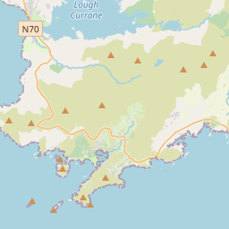
Based on data in OpenStreetMap, here is a list of townlands in the Electoral Division / ED / District Electoral Division of Baile an Sceilg.
Baile an Sceilg ist in der Grafschaft
Baile an Sceilg is not matched up to Logainm.ie yet.
Karte
Befindet sich bei 51° 49' 34" N, 10° 17' 52" W.


Leaflet | Map data © OpenStreetMap contributors
Fläche
Baile an Sceilg hat eine Fläche von 30,5 km² / 7,524,9 Acres / 11,8 Quadratmeilen.
Townlands
Uns sind 18 Townlands in bekannt. Das entspricht 100% der Fläche in .
- Alachaí Mór 493 A, 2 R, 26 P
- An Com 258 A, 3 R, 36 P
- Baile an Sceilg 723 A, 0 R, 35 P
- Bólas 429 A, 2 R, 14 P
- Buaile Uí Chuill 202 A, 3 R, 25 P
- Canuig 453 A, 2 R, 9 P
- Cill Rialaigh 432 A, 2 R, 11 P
- Cill Urlaí 717 A, 2 R, 0 P
- Cinn Aird Thiar 524 A, 2 R, 18 P
- Cinn Aird Thoir 403 A, 0 R, 1 P
- Clochán na nUagh 565 A, 0 R, 37 P
- Currach na nDamh 281 A, 2 R, 27 P
- Duichealla 412 A, 0 R, 29 P
- Dún Géagáin 216 A, 3 R, 27 P
- Mill an Ghoilín 238 A, 2 R, 14 P
- Na Cúla 736 A, 3 R, 29 P
- Na Leadhba Liatha 315 A, 1 R, 32 P
- Ré na gCúl 118 A, 0 R, 39 P
 OpenStreetMap
Baile an Sceilg wurde am 11 Jan 2017 von Teester bei OpenStreetMap erfasst.
- View
- Edit

 JOSM
JOSM iD
iD