Based on data in OpenStreetMap, here is a list of townlands in the Electoral Division / ED / District Electoral Division of Donaghpatrick.
Donaghpatrick ist in der Grafschaft
Donaghpatrick is not matched up to Logainm.ie yet.
Karte
Befindet sich bei 53° 42' 51" N, 6° 43' 9" W.


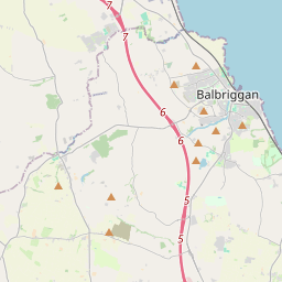
Leaflet | Map data © OpenStreetMap contributors
Fläche
Donaghpatrick hat eine Fläche von 42,5 km² / 10,500,6 Acres / 16,4 Quadratmeilen.
Townlands
Uns sind 22 Townlands in bekannt. Das entspricht 100% der Fläche in .
- Arch Hall 349 A, 3 R, 4 P
- Baile Ghib 318 A, 3 R, 22 P
- Baile Órthaí 128 A, 3 R, 13 P
- Balsaw 652 A, 1 R, 29 P
- Boolies 230 A, 2 R, 10 P
- Castletown Kilberry 421 A, 0 R, 33 P
- Cluain an Ghaill 1207 A, 2 R, 25 P
- Demailestown 718 A, 2 R, 2 P
- Diméin Bhaile Ghib 1040 A, 3 R, 21 P
- Domhnach Phádraig 185 A, 1 R, 2 P
- Dowthstown 66 A, 3 R, 24 P
- Fletcherstown 631 A, 3 R, 34 P
- Kilberry 565 A, 3 R, 35 P
- Milestown 173 A, 0 R, 19 P
- Moortown 194 A, 2 R, 22 P
- Mullaghard 66 A, 1 R, 17 P
- Randalstown 928 A, 3 R, 21 P
- Ráth an Tancardaigh 132 A, 3 R, 18 P
- Rathcoon 613 A, 1 R, 5 P
- Silloge 626 A, 2 R, 39 P
- Tatestown 340 A, 2 R, 16 P
- Wilkinstown 905 A, 0 R, 37 P
 OpenStreetMap
Donaghpatrick wurde am 11 Feb 2017 von Teester bei OpenStreetMap erfasst.
- View
- Edit