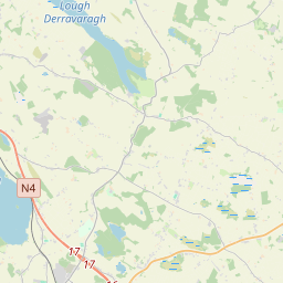
Based on data in OpenStreetMap, here is a list of townlands in Rathconnell.
Rathconnell ist in den Baronien Moyashel and Maheradermon.
Rathconnell ist in den Grafschaften Westmeath.
Rathconnell bei Logainm.ie: Rathconnell.
Karte
Befindet sich bei 53° 33' 42" N, 7° 13' 51" W.


Leaflet | Map data © OpenStreetMap contributors
Fläche
Rathconnell hat eine Fläche von 65,6 km² / 16,207,7 Acres / 25,3 Quadratmeilen.
Townlands
There are 32 townlands that we know about in Rathconnell. This represents 94,4% of all the area in Rathconnell.
- Aghadaugh, Gemeinde Rathconnell, Baronie Moyashel and Maheradermon, Grafschaft Westmeath 254 A, 2 R, 3 P
- Baile Mháis (see Macetown (Baile Mháis) , Gemeinde Rathconnell, Baronie Moyashel and Maheradermon, Grafschaft Westmeath)
- Ballycor, Gemeinde Rathconnell, Baronie Moyashel and Maheradermon, Grafschaft Westmeath 332 A, 2 R, 30 P
- Balrath East, Gemeinde Rathconnell, Baronie Moyashel and Maheradermon, Grafschaft Westmeath 383 A, 3 R, 22 P
- Balrath North, Gemeinde Rathconnell, Baronie Moyashel and Maheradermon, Grafschaft Westmeath 74 A, 0 R, 20 P
- Balrath West, Gemeinde Rathconnell, Baronie Moyashel and Maheradermon, Grafschaft Westmeath 97 A, 1 R, 4 P
- Balreagh, Gemeinde Rathconnell, Baronie Moyashel and Maheradermon, Grafschaft Westmeath 828 A, 0 R, 22 P
- Brittas, Gemeinde Rathconnell, Baronie Moyashel and Maheradermon, Grafschaft Westmeath 183 A, 1 R, 18 P
- Cartron, Gemeinde Rathconnell, Baronie Moyashel and Maheradermon, Grafschaft Westmeath 9 A, 3 R, 19 P
- Cill Fhíonáin (Cooke) (see Killynan (Cooke) (Cill Fhíonáin (Cooke)) , Gemeinde Rathconnell, Baronie Moyashel and Maheradermon, Grafschaft Westmeath)
- Cill Fhíonáin (Pratt) (see Killynan (Pratt) (Cill Fhíonáin (Pratt)) , Gemeinde Rathconnell, Baronie Moyashel and Maheradermon, Grafschaft Westmeath)
- Cloghanumera, Gemeinde Rathconnell, Baronie Moyashel and Maheradermon, Grafschaft Westmeath 36 A, 1 R, 2 P
- Clondalever, Gemeinde Rathconnell, Baronie Moyashel and Maheradermon, Grafschaft Westmeath 365 A, 2 R, 28 P
- Clonickilvant (Cluain Mhic Giolla Mhantaigh) , Gemeinde Rathconnell, Baronie Moyashel and Maheradermon, Grafschaft Westmeath 1164 A, 2 R, 21 P
- Clonkill, Gemeinde Rathconnell, Baronie Moyashel and Maheradermon, Grafschaft Westmeath 792 A, 1 R, 31 P
- Clonlost (Cluain Loiste) , Gemeinde Rathconnell, Baronie Moyashel and Maheradermon, Grafschaft Westmeath 821 A, 1 R, 38 P
- Clonsheever (Cluain Siabhair) , Gemeinde Rathconnell, Baronie Moyashel and Maheradermon, Grafschaft Westmeath 401 A, 1 R, 14 P
- Cluain Loiste (see Clonlost (Cluain Loiste) , Gemeinde Rathconnell, Baronie Moyashel and Maheradermon, Grafschaft Westmeath)
- Cluain Mhic Giolla Mhantaigh (see Clonickilvant (Cluain Mhic Giolla Mhantaigh) , Gemeinde Rathconnell, Baronie Moyashel and Maheradermon, Grafschaft Westmeath)
- Cluain Siabhair (see Clonsheever (Cluain Siabhair) , Gemeinde Rathconnell, Baronie Moyashel and Maheradermon, Grafschaft Westmeath)
- Cooksborough (Maigh gCuilinn) , Gemeinde Rathconnell, Baronie Moyashel and Maheradermon, Grafschaft Westmeath 921 A, 2 R, 6 P
- Crosserdree, Gemeinde Rathconnell, Baronie Moyashel and Maheradermon, Grafschaft Westmeath 264 A, 1 R, 7 P
- Curraghbrack, Gemeinde Rathconnell, Baronie Moyashel and Maheradermon, Grafschaft Westmeath 123 A, 1 R, 35 P
- Curraghmore, Gemeinde Rathconnell, Baronie Moyashel and Maheradermon, Grafschaft Westmeath 401 A, 1 R, 1 P
- Drinmore, Gemeinde Rathconnell, Baronie Moyashel and Maheradermon, Grafschaft Westmeath 129 A, 1 R, 13 P
- East Balrath (see Balrath East, Gemeinde Rathconnell, Baronie Moyashel and Maheradermon, Grafschaft Westmeath)
- Edmondstown, Gemeinde Rathconnell, Baronie Moyashel and Maheradermon, Grafschaft Westmeath 208 A, 2 R, 18 P
- Fennor (Fionnúir) , Gemeinde Rathconnell, Baronie Moyashel and Maheradermon, Grafschaft Westmeath 681 A, 1 R, 22 P
- Fionnúir (see Fennor (Fionnúir) , Gemeinde Rathconnell, Baronie Moyashel and Maheradermon, Grafschaft Westmeath)
- Gigginstown, Gemeinde Rathconnell, Baronie Moyashel and Maheradermon, Grafschaft Westmeath 561 A, 2 R, 22 P
- Jeffrystown, Gemeinde Rathconnell, Baronie Moyashel and Maheradermon, Grafschaft Westmeath 318 A, 2 R, 28 P
- Killynan (Cooke) (Cill Fhíonáin (Cooke)) , Gemeinde Rathconnell, Baronie Moyashel and Maheradermon, Grafschaft Westmeath 1094 A, 1 R, 32 P
- Killynan (Pratt) (Cill Fhíonáin (Pratt)) , Gemeinde Rathconnell, Baronie Moyashel and Maheradermon, Grafschaft Westmeath 1184 A, 0 R, 37 P
- Loughagar Beg, Gemeinde Rathconnell, Baronie Moyashel and Maheradermon, Grafschaft Westmeath 107 A, 2 R, 28 P
- Loughagar More, Gemeinde Rathconnell, Baronie Moyashel and Maheradermon, Grafschaft Westmeath 907 A, 2 R, 3 P
- Macetown (Baile Mháis) , Gemeinde Rathconnell, Baronie Moyashel and Maheradermon, Grafschaft Westmeath 989 A, 0 R, 16 P
- Maigh gCuilinn (see Cooksborough (Maigh gCuilinn) , Gemeinde Rathconnell, Baronie Moyashel and Maheradermon, Grafschaft Westmeath)
- Mountrobert, Gemeinde Rathconnell, Baronie Moyashel and Maheradermon, Grafschaft Westmeath 131 A, 0 R, 15 P
- North Balrath (see Balrath North, Gemeinde Rathconnell, Baronie Moyashel and Maheradermon, Grafschaft Westmeath)
- Rathconnell (Rú Chonaill) , Gemeinde Rathconnell, Baronie Moyashel and Maheradermon, Grafschaft Westmeath 576 A, 0 R, 31 P
- Reynella, Gemeinde Rathconnell, Baronie Moyashel and Maheradermon, Grafschaft Westmeath 606 A, 3 R, 29 P
- Rú Chonaill (see Rathconnell (Rú Chonaill) , Gemeinde Rathconnell, Baronie Moyashel and Maheradermon, Grafschaft Westmeath)
- Teamhairín (see Tevrin (Teamhairín) , Gemeinde Rathconnell, Baronie Moyashel and Maheradermon, Grafschaft Westmeath)
- Tevrin (Teamhairín) , Gemeinde Rathconnell, Baronie Moyashel and Maheradermon, Grafschaft Westmeath 344 A, 1 R, 6 P
- West Balrath (see Balrath West, Gemeinde Rathconnell, Baronie Moyashel and Maheradermon, Grafschaft Westmeath)
 OpenStreetMap
Rathconnell wurde am 28 Nov 2014 von brianboru bei OpenStreetMap erfasst.
- View
- Edit

 JOSM
JOSM iD
iD