Based on data in OpenStreetMap, here is a list of townlands in Bray.
Bray ist in den Baronien Rathdown.
Bray ist in den Grafschaften Wicklow.
Bray bei Logainm.ie: Bray.
Karte
Befindet sich bei 53° 11' 12" N, 6° 6' 27" W.
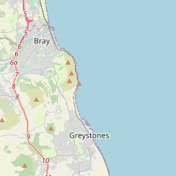

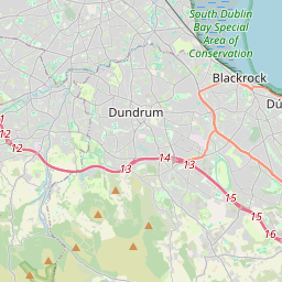

Leaflet | Map data © OpenStreetMap contributors
Fläche
Bray hat eine Fläche von 12,1 km² / 2,986,0 Acres / 4,7 Quadratmeilen.
Townlands
There are 14 townlands that we know about in Bray. This represents 100% of all the area in Bray.
- Baile Bhaltraim (see Ballywaltrim (Baile Bhaltraim) , Gemeinde Bray, Baronie Rathdown, Grafschaft Wicklow)
- An Baile Gaelach (see Irishtown (An Baile Gaelach) , Gemeinde Bray, Baronie Rathdown, Grafschaft Wicklow)
- Baile Mhuiris (see Ballymorris (Baile Mhuiris) , Gemeinde Bray, Baronie Rathdown, Grafschaft Wicklow)
- Ballymorris (Baile Mhuiris) , Gemeinde Bray, Baronie Rathdown, Grafschaft Wicklow 24 A, 3 R, 34 P
- Ballynamuddagh, Gemeinde Bray, Baronie Rathdown, Grafschaft Wicklow 471 A, 2 R, 30 P
- Ballywaltrim (Baile Bhaltraim) , Gemeinde Bray, Baronie Rathdown, Grafschaft Wicklow 114 A, 2 R, 31 P
- Bray (Bré) , Gemeinde Bray, Baronie Rathdown, Grafschaft Wicklow 438 A, 3 R, 8 P
- Bré (see Bray (Bré) , Gemeinde Bray, Baronie Rathdown, Grafschaft Wicklow)
- Cill Easpaig Sáráin (see Killarney (Cill Easpaig Sáráin) , Gemeinde Bray, Baronie Rathdown, Grafschaft Wicklow)
- Diméin Chill Ruaidhrí Thiar (see Kilruddery Demesne West (Diméin Chill Ruaidhrí Thiar) , Gemeinde Bray, Baronie Rathdown, Grafschaft Wicklow)
- Diméin Chill Ruaidhrí Thoir (see Kilruddery Demesne East (Diméin Chill Ruaidhrí Thoir) , Gemeinde Bray, Baronie Rathdown, Grafschaft Wicklow)
- East Kilruddery Demesne (see Kilruddery Demesne East (Diméin Chill Ruaidhrí Thoir) , Gemeinde Bray, Baronie Rathdown, Grafschaft Wicklow)
- Giltspur (Giolaspar) , Gemeinde Bray, Baronie Rathdown, Grafschaft Wicklow 213 A, 0 R, 22 P
- Giolaspar (see Giltspur (Giolaspar) , Gemeinde Bray, Baronie Rathdown, Grafschaft Wicklow)
- Irishtown (An Baile Gaelach) , Gemeinde Bray, Baronie Rathdown, Grafschaft Wicklow 104 A, 0 R, 6 P
- Kilbride, Gemeinde Bray, Baronie Rathdown, Grafschaft Wicklow 139 A, 0 R, 0 P
- Killarney (Cill Easpaig Sáráin) , Gemeinde Bray, Baronie Rathdown, Grafschaft Wicklow 179 A, 1 R, 22 P
- Kilruddery Deerpark, Gemeinde Bray, Baronie Rathdown, Grafschaft Wicklow 269 A, 2 R, 2 P
- Kilruddery Demesne East (Diméin Chill Ruaidhrí Thoir) , Gemeinde Bray, Baronie Rathdown, Grafschaft Wicklow 69 A, 3 R, 30 P
- Kilruddery Demesne West (Diméin Chill Ruaidhrí Thiar) , Gemeinde Bray, Baronie Rathdown, Grafschaft Wicklow 349 A, 3 R, 12 P
- Newcourt, Gemeinde Bray, Baronie Rathdown, Grafschaft Wicklow 274 A, 1 R, 38 P
- Oldcourt (An tSeanchúirt) , Gemeinde Bray, Baronie Rathdown, Grafschaft Wicklow 315 A, 3 R, 6 P
- An tSeanchúirt (see Oldcourt (An tSeanchúirt) , Gemeinde Bray, Baronie Rathdown, Grafschaft Wicklow)
- Springfield, Gemeinde Bray, Baronie Rathdown, Grafschaft Wicklow 20 A, 2 R, 29 P
- West Kilruddery Demesne (see Kilruddery Demesne West (Diméin Chill Ruaidhrí Thiar) , Gemeinde Bray, Baronie Rathdown, Grafschaft Wicklow)
 OpenStreetMap
Bray wurde am 10 Apr 2016 von rorym bei OpenStreetMap erfasst.
- View
- Edit