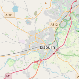
Based on data in OpenStreetMap, here is a list of townlands in Blaris (Iveagh portion).
Blaris (Iveagh portion) is in the baronies of Iveagh Lower, Upper Half.
Blaris (Iveagh portion) is in the counties of Down.
Blaris (Iveagh portion) is not matched up to Logainm.ie yet.
Map
It is located at 54° 28' 51" N, 6° 5' 21" W.


Leaflet | Map data © OpenStreetMap contributors
Area
Blaris (Iveagh portion) has an area of 19.4 km² / 4,805.9 acres / 7.5 square miles.
Townlands
There are 9 townlands that we know about in Blaris (Iveagh portion). This represents 100% of all the area in Blaris (Iveagh portion).
- Achadh na Triosca (see Aghnatrisk (Achadh na Triosca) , Blaris (Iveagh portion) Civil Parish, Barony of Iveagh Lower, Upper Half, Co. Down)
- Aghnatrisk (Achadh na Triosca) , Blaris (Iveagh portion) Civil Parish, Barony of Iveagh Lower, Upper Half, Co. Down 252 A, 0 R, 4 P
- Annacloy (Áth na Cloiche) , Blaris (Iveagh portion) Civil Parish, Barony of Iveagh Lower, Upper Half, Co. Down 192 A, 0 R, 8 P
- Áth na Cloiche (see Annacloy (Áth na Cloiche) , Blaris (Iveagh portion) Civil Parish, Barony of Iveagh Lower, Upper Half, Co. Down)
- An Baile Caol Éadan Ó gConaill (see Ballykeel Edenagonnell (An Baile Caol Éadan Ó gConaill) , Blaris (Iveagh portion) Civil Parish, Barony of Iveagh Lower, Upper Half, Co. Down)
- Ballykeel Edenagonnell (An Baile Caol Éadan Ó gConaill) , Blaris (Iveagh portion) Civil Parish, Barony of Iveagh Lower, Upper Half, Co. Down 234 A, 0 R, 34 P
- An Carn Bán (see Carnbane (An Carn Bán) , Blaris (Iveagh portion) Civil Parish, Barony of Iveagh Lower, Upper Half, Co. Down)
- An Carn Riabhach (see Carnreagh (An Carn Riabhach) , Blaris (Iveagh portion) Civil Parish, Barony of Iveagh Lower, Upper Half, Co. Down)
- Carnbane (An Carn Bán) , Blaris (Iveagh portion) Civil Parish, Barony of Iveagh Lower, Upper Half, Co. Down 527 A, 1 R, 18 P
- Carnreagh (An Carn Riabhach) , Blaris (Iveagh portion) Civil Parish, Barony of Iveagh Lower, Upper Half, Co. Down 408 A, 3 R, 37 P
- Cúil Chéibhe (see Culcavy (Cúil Chéibhe) , Blaris (Iveagh portion) Civil Parish, Barony of Iveagh Lower, Upper Half, Co. Down)
- Culcavy (Cúil Chéibhe) , Blaris (Iveagh portion) Civil Parish, Barony of Iveagh Lower, Upper Half, Co. Down 795 A, 3 R, 8 P
- Machaire na gCaorach (see Magherageery (Machaire na gCaorach) , Blaris (Iveagh portion) Civil Parish, Barony of Iveagh Lower, Upper Half, Co. Down)
- Magherageery (Machaire na gCaorach) , Blaris (Iveagh portion) Civil Parish, Barony of Iveagh Lower, Upper Half, Co. Down 432 A, 2 R, 12 P
- Maze, Blaris (Iveagh portion) Civil Parish, Barony of Iveagh Lower, Upper Half, Co. Down 1557 A, 3 R, 21 P
- Ráth Bhearnáin (see Ravernet (Ráth Bhearnáin) , Blaris (Iveagh portion) Civil Parish, Barony of Iveagh Lower, Upper Half, Co. Down)
- Ravernet (Ráth Bhearnáin) , Blaris (Iveagh portion) Civil Parish, Barony of Iveagh Lower, Upper Half, Co. Down 404 A, 3 R, 37 P
 OpenStreetMap
Blaris (Iveagh portion) was added to OpenStreetMap on 2 Aug 2016 by Stephen_Co_Antrim.
- View
- Edit

 JOSM
JOSM iD
iD