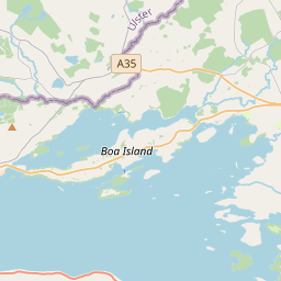
Based on data in OpenStreetMap, here is a list of townlands in the Electoral Division / ED / District Electoral Division of Clonelly.
Clonelly is in Co.
Clonelly is not matched up to Logainm.ie yet.
Map
It is located at 54° 32' 52" N, 7° 47' 43" W.


Leaflet | Map data © OpenStreetMap contributors
Area
Clonelly has an area of 16.0 km² / 3,953.1 acres / 6.2 square miles.
Townlands
There are 29 townlands that we know about in . This represents 100% of all the area in .
- Aghahannagh 211 A, 2 R, 4 P
- Aghalaan 111 A, 3 R, 11 P
- Ardore 111 A, 0 R, 24 P
- Backwood 40 A, 1 R, 39 P
- Ballynabrannagh 59 A, 3 R, 35 P
- Bigwood or Drumkeeran 82 A, 2 R, 2 P
- Boolawater 119 A, 2 R, 23 P
- Carrickoughter 266 A, 1 R, 27 P
- Clonaweel 219 A, 3 R, 30 P
- Clonelly 251 A, 1 R, 14 P
- Corlaght West 78 A, 2 R, 32 P
- Crockateggal 37 A, 2 R, 27 P
- Curraghmore 344 A, 1 R, 2 P
- Derrybrick 89 A, 2 R, 23 P
- Drumgowna West 313 A, 0 R, 1 P
- Drumlongfield 97 A, 1 R, 38 P
- Firs 32 A, 3 R, 18 P
- Glennagarran 113 A, 0 R, 30 P
- Gortacar 234 A, 2 R, 12 P
- Killynoogan 76 A, 1 R, 19 P
- Kilmore 98 A, 0 R, 21 P
- Larmore 77 A, 0 R, 33 P
- Lowery 293 A, 3 R, 35 P
- Lurganboy 66 A, 0 R, 29 P
- New Park 45 A, 0 R, 25 P
- Rossgole 138 A, 1 R, 24 P
- Springtown 120 A, 0 R, 21 P
- Stragolan 97 A, 3 R, 23 P
- Tullyhommon 123 A, 1 R, 28 P
 OpenStreetMap
Clonelly was added to OpenStreetMap on 14 Feb 2021 by brianh.
- View
- Edit

 JOSM
JOSM iD
iD