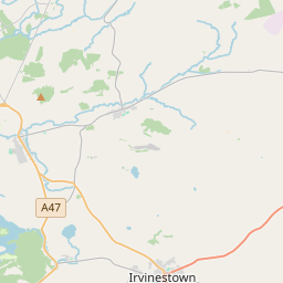
Based on data in OpenStreetMap, here is a list of townlands in the Electoral Division / ED / District Electoral Division of Drumkeeran.
Drumkeeran is in Co.
Drumkeeran is not matched up to Logainm.ie yet.
Map
It is located at 54° 34' 28" N, 7° 42' 2" W.


Leaflet | Map data © OpenStreetMap contributors
Area
Drumkeeran has an area of 17.3 km² / 4,270.1 acres / 6.7 square miles.
Townlands
There are 20 townlands that we know about in . This represents 100% of all the area in .
- Camplagh 161 A, 2 R, 2 P
- Carrickcroghery 177 A, 1 R, 35 P
- Derryneeve 118 A, 0 R, 5 P
- Drumchorick 216 A, 1 R, 30 P
- Drumcullion 201 A, 2 R, 3 P
- Drumduff 190 A, 0 R, 26 P
- Drummoney 254 A, 1 R, 36 P
- Drumnagalliagh 359 A, 2 R, 6 P
- Drumnagreshial 145 A, 3 R, 23 P
- Drumskinny 291 A, 3 R, 37 P
- Edenticromman 177 A, 1 R, 13 P
- Gortnagullion 378 A, 3 R, 18 P
- Lugmore 105 A, 3 R, 13 P
- Meentullyclogh 91 A, 1 R, 0 P
- Montiaghroe 270 A, 1 R, 7 P
- Rotten Mountain 352 A, 3 R, 38 P
- Tawnydorragh 135 A, 2 R, 17 P
- Tievaveeny 243 A, 1 R, 37 P
- Tievenavarnog 155 A, 3 R, 1 P
- Tullynashammer 241 A, 2 R, 25 P
 OpenStreetMap
Drumkeeran was added to OpenStreetMap on 13 Feb 2021 by brianh.
- View
- Edit

 JOSM
JOSM iD
iD