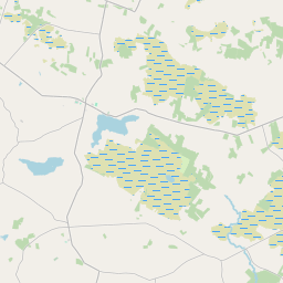
Based on data in OpenStreetMap, here is a list of townlands in the Electoral Division / ED / District Electoral Division of Cloonkeen.
Cloonkeen is in Co.
Cloonkeen is not matched up to Logainm.ie yet.
Map
It is located at 53° 32' 13" N, 8° 25' 21" W.


Leaflet | Map data © OpenStreetMap contributors
Area
Cloonkeen has an area of 21.2 km² / 5,234.5 acres / 8.2 square miles.
Townlands
There are 20 townlands that we know about in . This represents 100% of all the area in .
- Ballynacorra (Davies) 110 A, 2 R, 10 P
- Ballynacorra (Ffrench) 349 A, 1 R, 22 P
- Ballynacorra (Netterville) 110 A, 3 R, 16 P
- Bleannagloos 373 A, 1 R, 16 P
- Boggauns 420 A, 1 R, 14 P
- Cappagh 387 A, 1 R, 3 P
- Cloonfinnoge 98 A, 1 R, 30 P
- Cloonkeen 165 A, 2 R, 39 P
- Cloonkeen 93 A, 1 R, 22 P
- Cloonkeen 122 A, 3 R, 37 P
- Cloonkeen (Netterville) 95 A, 2 R, 22 P
- Cloonshivna 272 A, 2 R, 27 P
- Cloonshivna (Kelly) 282 A, 2 R, 18 P
- Creeveroe (Davies) 127 A, 2 R, 13 P
- Creeveroe (Ffrench) 272 A, 1 R, 20 P
- Kentstown 99 A, 1 R, 16 P
- Kilclogh 422 A, 0 R, 18 P
- Kilcoosh 382 A, 0 R, 32 P
- Lissavruggy 512 A, 2 R, 7 P
- Saint Brendan's 535 A, 0 R, 8 P
 OpenStreetMap
Cloonkeen was added to OpenStreetMap on 18 Dec 2016 by Boggedy.
- View
- Edit

 JOSM
JOSM iD
iD