Based on data in OpenStreetMap, here is a list of townlands in the Electoral Division / ED / District Electoral Division of Cong.
Cong is in Co.
Cong is not matched up to Logainm.ie yet.
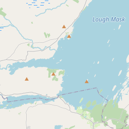
Map
It is located at 53° 30' 19" N, 9° 24' 21" W.


Leaflet | Map data © OpenStreetMap contributors
Area
Cong has an area of 93.2 km² / 23,025.9 acres / 36.0 square miles.
Townlands
There are 42 townlands that we know about in . This represents 50.7% of all the area in .
- An Móinín Mór 658 A, 0 R, 16 P
- Ballydoolough 706 A, 2 R, 2 P
- Bohaun 445 A, 1 R, 12 P
- Burr Island 4 A, 0 R, 2 P
- Cannaver Island 15 A, 1 R, 11 P
- Carrick East 597 A, 3 R, 15 P
- Carrick Middle 375 A, 2 R, 9 P
- Carrick West 340 A, 3 R, 0 P
- Carrowgarriff 675 A, 2 R, 22 P
- Claggan 413 A, 0 R, 31 P
- Cloonbrone 327 A, 1 R, 8 P
- Cornamona (Townland of) 352 A, 0 R, 26 P
- Crumlin East 1649 A, 0 R, 38 P
- Dooghta 1576 A, 1 R, 33 P
- Dooneen Island 5 A, 1 R, 24 P
- Dooros 571 A, 2 R, 15 P
- Drishaghaun 518 A, 0 R, 12 P
- Drumsnauv 510 A, 0 R, 31 P
- Farnaght 267 A, 1 R, 34 P
- Glenlusk 424 A, 0 R, 38 P
- Illaunagawna 3 A, 3 R, 21 P
- Illaunaknick 4 A, 2 R, 2 P
- Illaunanarrew 4 A, 1 R, 38 P
- Illaundaulaur 6 A, 2 R, 4 P
- Illaundonoghrevy 5 A, 0 R, 5 P
- Illaunleenagh 3 A, 3 R, 24 P
- Illaunribbeen 18 A, 2 R, 30 P
- Inchagoill 108 A, 3 R, 23 P
- Inishannagh 14 A, 3 R, 23 P
- Inishbiana 12 A, 3 R, 32 P
- Inishdauwee 32 A, 2 R, 37 P
- Inishdoorus 166 A, 3 R, 7 P
- Inishmicatreer 274 A, 3 R, 9 P
- Inishnanean 6 A, 2 R, 16 P
- Inishthee 11 A, 0 R, 13 P
- Inishvinlush 4 A, 3 R, 18 P
- Kelly's Island 5 A, 3 R, 20 P
- Roeillaunbaun 3 A, 1 R, 30 P
- Roeillaundoo 9 A, 0 R, 29 P
- Smith's Island 4 A, 2 R, 30 P
- Teeranea 540 A, 0 R, 38 P
- Wood Island 5 A, 1 R, 29 P
 OpenStreetMap
Cong was added to OpenStreetMap on 12 Oct 2014 by Boggedy.
- View
- Edit

 JOSM
JOSM iD
iD