Based on data in OpenStreetMap, here is a list of townlands in Inis Meáin.
Inis Meáin is in the baronies of Aran.
Inis Meáin is in the counties of Galway.
Inis Meáin is on Logainm.ie: Inis Meáin.
Map
It is located at 53° 5' 0" N, 9° 35' 25" W.
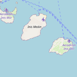


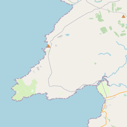
Leaflet | Map data © OpenStreetMap contributors
Area
Inis Meáin has an area of 9.8 km² / 2,431.8 acres / 3.8 square miles.
Townlands
There are 2 townlands that we know about in Inis Meáin. This represents 100% of all the area in Inis Meáin.
- Carrownlisheen (Ceathrú an Lisín) , Inis Meáin Civil Parish, Barony of Aran, Co. Galway 1209 A, 3 R, 0 P
- Carrowntemple (Ceathrú an Teampaill) , Inis Meáin Civil Parish, Barony of Aran, Co. Galway 1222 A, 0 R, 14 P
- Ceathrú an Lisín (see Carrownlisheen (Ceathrú an Lisín) , Inis Meáin Civil Parish, Barony of Aran, Co. Galway)
- Ceathrú an Teampaill (see Carrowntemple (Ceathrú an Teampaill) , Inis Meáin Civil Parish, Barony of Aran, Co. Galway)
 OpenStreetMap
Inis Meáin was added to OpenStreetMap on 20 Nov 2013 by Boggedy.
- View
- Edit