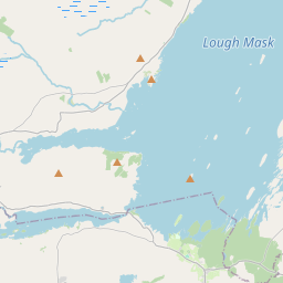
Based on data in OpenStreetMap, here is a list of townlands in the Electoral Division / ED / District Electoral Division of Killursa.
Killursa is in Co.
Killursa is not matched up to Logainm.ie yet.
Map
It is located at 53° 27' 17" N, 9° 11' 9" W.


Leaflet | Map data © OpenStreetMap contributors
Area
Killursa has an area of 42.5 km² / 10,498.5 acres / 16.4 square miles.
Townlands
There are 29 townlands that we know about in . This represents 71.8% of all the area in .
- Annaghkeen 661 A, 3 R, 26 P
- Ardfintan 176 A, 3 R, 14 P
- Ballyconlought 290 A, 0 R, 7 P
- Ballyhale 366 A, 0 R, 6 P
- Ballynacregga 227 A, 2 R, 0 P
- Ballynalacka 122 A, 2 R, 19 P
- Cahermacanally 198 A, 1 R, 23 P
- Cargin 139 A, 1 R, 9 P
- Carrowbeg 236 A, 3 R, 19 P
- Carrownacroagh 315 A, 3 R, 34 P
- Carrownakib 518 A, 3 R, 38 P
- Clerhaun 591 A, 3 R, 34 P
- Cloonkeely 112 A, 3 R, 27 P
- Cloononaghaun 268 A, 0 R, 15 P
- Clydagh 337 A, 2 R, 9 P
- Curraghmore 421 A, 1 R, 15 P
- Farrangavnagh 57 A, 1 R, 6 P
- Inchiquin 294 A, 2 R, 26 P
- Inishskehan 9 A, 2 R, 20 P
- Kilbeg 260 A, 1 R, 1 P
- Long Island North 1 A, 0 R, 9 P
- Luggawannia 250 A, 1 R, 25 P
- Ower 657 A, 3 R, 30 P
- Parkgarve 118 A, 0 R, 9 P
- Rinnaknock 98 A, 1 R, 29 P
- Shanbally 179 A, 0 R, 34 P
- Shrub Island 1 A, 3 R, 4 P
- Slieveroe 507 A, 2 R, 33 P
- Ulrith 117 A, 0 R, 29 P
 OpenStreetMap
Killursa was added to OpenStreetMap on 20 Sep 2014 by Boggedy.
- View
- Edit

 JOSM
JOSM iD
iD