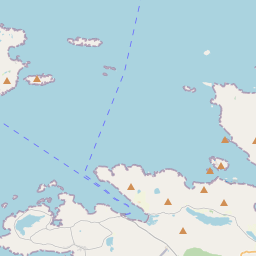
Based on data in OpenStreetMap, here is a list of townlands in the Electoral Division / ED / District Electoral Division of Sillerna.
Sillerna is in Co.
Sillerna is not matched up to Logainm.ie yet.
Map
It is located at 53° 32' 27" N, 10° 8' 23" W.


Leaflet | Map data © OpenStreetMap contributors
Area
Sillerna has an area of 24.4 km² / 6,018.2 acres / 9.4 square miles.
Townlands
There are 28 townlands that we know about in . This represents 100% of all the area in .
- Attigoddaun 187 A, 2 R, 7 P
- Aughrus Beg 497 A, 1 R, 37 P
- Aughrus More 486 A, 3 R, 4 P
- Barnahallia 84 A, 2 R, 12 P
- Cartoorbeg 79 A, 3 R, 39 P
- Claddaghduff 420 A, 3 R, 39 P
- Cloon 101 A, 1 R, 11 P
- Courhoor 529 A, 0 R, 19 P
- Cruagh 108 A, 1 R, 29 P
- Cushatrough 501 A, 0 R, 16 P
- Emlagh 312 A, 1 R, 13 P
- Friar Island 41 A, 1 R, 13 P
- Gannoughs 263 A, 2 R, 32 P
- Glen 293 A, 3 R, 8 P
- Gooreen 194 A, 3 R, 31 P
- Gooreenatinny 131 A, 1 R, 12 P
- Grallagh 177 A, 0 R, 39 P
- High Island 103 A, 2 R, 11 P
- Knocakavilra 152 A, 1 R, 7 P
- Leagaun 109 A, 2 R, 5 P
- Malthooa 18 A, 1 R, 20 P
- Maw 427 A, 3 R, 27 P
- Moorneen 276 A, 0 R, 17 P
- Patches 155 A, 1 R, 16 P
- Roeillaun 14 A, 2 R, 31 P
- Rossadillisk 188 A, 1 R, 6 P
- Rusheen (Omey) 61 A, 2 R, 17 P
- Sturrakeen 98 A, 1 R, 21 P
 OpenStreetMap
Sillerna was added to OpenStreetMap on 20 Oct 2014 by Boggedy.
- View
- Edit

 JOSM
JOSM iD
iD