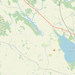
Based on data in OpenStreetMap, here is a list of townlands in the Electoral Division / ED / District Electoral Division of Kilbixy.
Kilbixy is in Co.
Kilbixy is not matched up to Logainm.ie yet.
Map
It is located at 53° 35' 44" N, 7° 30' 55" W.


Leaflet | Map data © OpenStreetMap contributors
Area
Kilbixy has an area of 24.4 km² / 6,039.7 acres / 9.4 square miles.
Townlands
There are 21 townlands that we know about in . This represents 99.1% of all the area in .
- Abbeyland and Charlestown or Ballynamonaster 242 A, 1 R, 12 P
- Ballallen 444 A, 1 R, 39 P
- Ballintue 665 A, 2 R, 12 P
- Ballycorkey 401 A, 0 R, 10 P
- Ballyhoreen 213 A, 3 R, 3 P
- Ballynacarrigy 148 A, 0 R, 3 P
- Ballynacarrigy Old 175 A, 2 R, 1 P
- Ballynacroghy or Gallowstown 355 A, 1 R, 37 P
- Baronstown 171 A, 1 R, 9 P
- Baronstown Demesne 1026 A, 1 R, 24 P
- Cumminstown 430 A, 1 R, 34 P
- Deerpark 112 A, 0 R, 7 P
- Grange 341 A, 2 R, 19 P
- Kilbixy 56 A, 0 R, 39 P
- Kilmacnevan 240 A, 1 R, 8 P
- Laragh 146 A, 0 R, 14 P
- Moranstown 46 A, 0 R, 1 P
- Rath 112 A, 3 R, 29 P
- Toor Commons 15 A, 1 R, 1 P
- Tristernagh 159 A, 3 R, 26 P
- Tristernagh Demesne 480 A, 2 R, 12 P
 OpenStreetMap
Kilbixy was added to OpenStreetMap on 6 Feb 2017 by Teester.
- View
- Edit

 JOSM
JOSM iD
iD