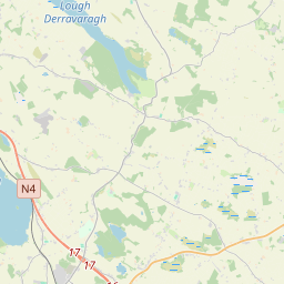
Based on data in OpenStreetMap, here is a list of townlands in St Feighin's.
St Feighin's is in the baronies of Fore.
St Feighin's is in the counties of Westmeath.
St Feighin's is on Logainm.ie: St Feighin's.
Map
It is located at 53° 40' 48" N, 7° 14' 32" W.


Leaflet | Map data © OpenStreetMap contributors
Area
St Feighin's has an area of 43.9 km² / 10,853.9 acres / 17.0 square miles.
Townlands
There are 19 townlands that we know about in St Feighin's. This represents 91.4% of all the area in St Feighin's.
- Baile an Chnoic (see Hilltown (Baile an Chnoic) , St Feighin's Civil Parish, Barony of Fore, Co. Westmeath)
- Baile Fhobhair (see Fore (Baile Fhobhair) , St Feighin's Civil Parish, Barony of Fore, Co. Westmeath)
- Baile na gCailleach (see Collinstown (Baile na gCailleach) , St Feighin's Civil Parish, Barony of Fore, Co. Westmeath)
- Ballany, St Feighin's Civil Parish, Barony of Fore, Co. Westmeath 444 A, 1 R, 31 P
- Barbavilla Demesne, St Feighin's Civil Parish, Barony of Fore, Co. Westmeath 581 A, 3 R, 13 P
- Ben (An Bhinn) , St Feighin's Civil Parish, Barony of Fore, Co. Westmeath 459 A, 0 R, 25 P
- Benisonlodge or Bratty, St Feighin's Civil Parish, Barony of Fore, Co. Westmeath 450 A, 1 R, 3 P
- An Bhinn (see Ben (An Bhinn) , St Feighin's Civil Parish, Barony of Fore, Co. Westmeath)
- Bratty (see Benisonlodge or Bratty, St Feighin's Civil Parish, Barony of Fore, Co. Westmeath)
- Carpenterstown, St Feighin's Civil Parish, Barony of Fore, Co. Westmeath 786 A, 2 R, 28 P
- Clonnageeragh, St Feighin's Civil Parish, Barony of Fore, Co. Westmeath 676 A, 2 R, 31 P
- Collinstown (Baile na gCailleach) , St Feighin's Civil Parish, Barony of Fore, Co. Westmeath 673 A, 0 R, 13 P
- Corbally, St Feighin's Civil Parish, Barony of Fore, Co. Westmeath 421 A, 1 R, 9 P
- Fore (Baile Fhobhair) , St Feighin's Civil Parish, Barony of Fore, Co. Westmeath 136 A, 0 R, 15 P
- Gillardstown, St Feighin's Civil Parish, Barony of Fore, Co. Westmeath 930 A, 1 R, 17 P
- Hammondstown and Tonaghmore, St Feighin's Civil Parish, Barony of Fore, Co. Westmeath 546 A, 0 R, 30 P
- Hilltown (Baile an Chnoic) , St Feighin's Civil Parish, Barony of Fore, Co. Westmeath 683 A, 3 R, 7 P
- Lakill and Moortown, St Feighin's Civil Parish, Barony of Fore, Co. Westmeath 834 A, 0 R, 27 P
- Loughanavagh or Newpark, St Feighin's Civil Parish, Barony of Fore, Co. Westmeath 183 A, 2 R, 15 P
- Loughpark, St Feighin's Civil Parish, Barony of Fore, Co. Westmeath 169 A, 2 R, 8 P
- Moortown (see Lakill and Moortown, St Feighin's Civil Parish, Barony of Fore, Co. Westmeath)
- Newpark (see Loughanavagh or Newpark, St Feighin's Civil Parish, Barony of Fore, Co. Westmeath)
- Ranaghan, St Feighin's Civil Parish, Barony of Fore, Co. Westmeath 649 A, 3 R, 4 P
- Templanstown, St Feighin's Civil Parish, Barony of Fore, Co. Westmeath 202 A, 0 R, 39 P
- Tóin na Seamar (see Tonashammer (Tóin na Seamar) , St Feighin's Civil Parish, Barony of Fore, Co. Westmeath)
- Tonaghmore (see Hammondstown and Tonaghmore, St Feighin's Civil Parish, Barony of Fore, Co. Westmeath)
- Tonashammer (Tóin na Seamar) , St Feighin's Civil Parish, Barony of Fore, Co. Westmeath 544 A, 1 R, 22 P
- Windtown, St Feighin's Civil Parish, Barony of Fore, Co. Westmeath 547 A, 3 R, 14 P
 OpenStreetMap
St Feighin's was added to OpenStreetMap on 26 Nov 2014 by brianboru.
- View
- Edit

 JOSM
JOSM iD
iD