Based on data in OpenStreetMap, here is a list of townlands in Montiaghs.
Montiaghs fait partie des baronnies de Oneilland East.
Montiaghs fait partie des comtés de Armagh.
Montiaghs is not matched up to Logainm.ie yet.
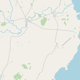
Carte
Il est situé à 54° 29' 36" N, 6° 26' 53" W.
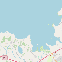

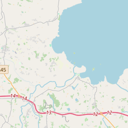
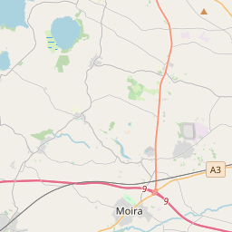
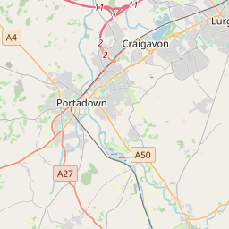

Leaflet | Map data © OpenStreetMap contributors
Superficie
Montiaghs a une superficie de 26,2 km² / 6,474,8 acres / 10,1 miles carrés.
Townlands
There are 10 townlands that we know about in Montiaghs. This represents 100% of all the area in Montiaghs.
- An Aird Mhór (see Ardmore (An Aird Mhór) , Paroisse civile Montiaghs, Baronnie de Oneilland East, Comté Armagh)
- Ardmore (An Aird Mhór) , Paroisse civile Montiaghs, Baronnie de Oneilland East, Comté Armagh 432 A, 2 R, 15 P
- Baile an oirimh (see Ballynery (Baile an oirimh) , Paroisse civile Montiaghs, Baronnie de Oneilland East, Comté Armagh)
- Ballynery (Baile an oirimh) , Paroisse civile Montiaghs, Baronnie de Oneilland East, Comté Armagh 803 A, 2 R, 34 P
- Darach Uí Thaidhg (see Derrytagh South (Darach Uí Thaidhg) , Paroisse civile Montiaghs, Baronnie de Oneilland East, Comté Armagh)
- Derryadd (Doire Fhada) , Paroisse civile Montiaghs, Baronnie de Oneilland East, Comté Armagh 781 A, 0 R, 5 P
- Derrycor (Doire Corr) , Paroisse civile Montiaghs, Baronnie de Oneilland East, Comté Armagh 321 A, 1 R, 6 P
- Derryinver (Doire Inbhir) , Paroisse civile Montiaghs, Baronnie de Oneilland East, Comté Armagh 1067 A, 3 R, 33 P
- Derryloste (Doire loiste) , Paroisse civile Montiaghs, Baronnie de Oneilland East, Comté Armagh 563 A, 2 R, 22 P
- Derrymacash (Doire Mhic Chais) , Paroisse civile Montiaghs, Baronnie de Oneilland East, Comté Armagh 815 A, 1 R, 25 P
- Derrytagh North (Doire Trasna) , Paroisse civile Montiaghs, Baronnie de Oneilland East, Comté Armagh 286 A, 3 R, 37 P
- Derrytagh South (Darach Uí Thaidhg) , Paroisse civile Montiaghs, Baronnie de Oneilland East, Comté Armagh 529 A, 3 R, 27 P
- Derrytrasna (Doire Trasna) , Paroisse civile Montiaghs, Baronnie de Oneilland East, Comté Armagh 872 A, 1 R, 0 P
- Doire Corr (see Derrycor (Doire Corr) , Paroisse civile Montiaghs, Baronnie de Oneilland East, Comté Armagh)
- Doire Fhada (see Derryadd (Doire Fhada) , Paroisse civile Montiaghs, Baronnie de Oneilland East, Comté Armagh)
- Doire Inbhir (see Derryinver (Doire Inbhir) , Paroisse civile Montiaghs, Baronnie de Oneilland East, Comté Armagh)
- Doire loiste (see Derryloste (Doire loiste) , Paroisse civile Montiaghs, Baronnie de Oneilland East, Comté Armagh)
- Doire Mhic Chais (see Derrymacash (Doire Mhic Chais) , Paroisse civile Montiaghs, Baronnie de Oneilland East, Comté Armagh)
- Doire Trasna (see Derrytagh North (Doire Trasna) , Paroisse civile Montiaghs, Baronnie de Oneilland East, Comté Armagh)
- Doire Trasna (see Derrytrasna (Doire Trasna) , Paroisse civile Montiaghs, Baronnie de Oneilland East, Comté Armagh)
- North Derrytagh (see Derrytagh North (Doire Trasna) , Paroisse civile Montiaghs, Baronnie de Oneilland East, Comté Armagh)
- South Derrytagh (see Derrytagh South (Darach Uí Thaidhg) , Paroisse civile Montiaghs, Baronnie de Oneilland East, Comté Armagh)
 OpenStreetMap
Montiaghs a été ajouté à OpenStreetMap le 23 Jul 2016 par Stephen_Co_Antrim.
- View
- Edit