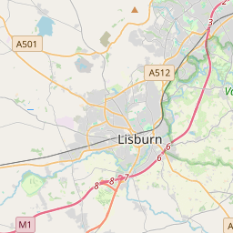
Based on data in OpenStreetMap, here is a list of townlands in the Electoral Division / ED / District Electoral Division of Derryaghy.
Derryaghy is in Co.
Derryaghy is not matched up to Logainm.ie yet.
Léarscáil
It is located at 54° 33' 10" N, 6° 2' 55" W.


Leaflet | Map data © OpenStreetMap contributors
Achar
Derryaghy has an area of 26.9 km² / 6,656.6 acres / 10.4 square miles.
Ceannbhailte
There are 16 townlands that we know about in . This represents 100% of all the area in .
- Achadh Lis Luain 427 A, 3 R, 30 P
- Achadh Lis Luain 261 A, 1 R, 22 P
- Baile-Ui-Coileain 620 A, 0 R, 1 P
- Doire Achaidh 572 A, 3 R, 18 P
- Coill Eatain 239 A, 1 R, 0 P
- Coill Mic Ciaigh 334 A, 3 R, 1 P
- Lag Mór 692 A, 0 R, 1 P
- Lann Bheag 204 A, 3 R, 8 P
- Lann Bheag 190 A, 0 R, 28 P
- Machaire Shléibhe 153 A, 3 R, 30 P
- Machaire Shléibhe 754 A, 2 R, 1 P
- Mullach Glas 898 A, 2 R, 27 P
- Poll Glas 396 A, 1 R, 9 P
- Sliabh na Cloiche 293 A, 1 R, 17 P
- Sliabh na gCraobh Righ 335 A, 3 R, 0 P
- Tor na Righ 280 A, 3 R, 15 P
 OpenStreetMap
Derryaghy was added to OpenStreetMap on 26 Feabh 2021 by b-unicycling.
- View
- Edit

 JOSM
JOSM iD
iD