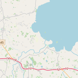
Based on data in OpenStreetMap, here is a list of townlands in the Electoral Division / ED / District Electoral Division of Kilmore.
Kilmore is in Co.
Kilmore is not matched up to Logainm.ie yet.
Léarscáil
It is located at 54° 24' 11" N, 6° 33' 19" W.


Leaflet | Map data © OpenStreetMap contributors
Achar
Kilmore has an area of 16.6 km² / 4,108.7 acres / 6.4 square miles.
Ceannbhailte
There are 20 townlands that we know about in . This represents 100% of all the area in .
- Eanach Bó 354 A, 1 R, 36 P
- Eanach aodha 292 A, 2 R, 19 P
- Ard riach 163 A, 1 R, 17 P
- Baile Uí Agáin 157 A, 1 R, 2 P
- Baile tSrotha 162 A, 0 R, 0 P
- Baile Tíre Eoghain 265 A, 1 R, 5 P
- Baile an Mhullaigh 197 A, 1 R, 30 P
- Baile an Chéide Móir 201 A, 2 R, 17 P
- Cabhán 167 A, 1 R, 9 P
- Cluain Droichid 402 A, 3 R, 29 P
- Críonach 272 A, 1 R, 32 P
- Drom Ard 248 A, 2 R, 39 P
- Droim Mullaigh 265 A, 2 R, 37 P
- Coill Mhic Cáinte 125 A, 3 R, 10 P
- Cill Mhór Mhorainn 86 A, 0 R, 19 P
- Lissheffield (Kilmore portion) 49 A, 0 R, 14 P
- Lios Síthiúl 137 A, 2 R, 7 P
- Lorgainn Cat 218 A, 2 R, 0 P
- An Mhuine 172 A, 3 R, 3 P
- Tír an Ghairrdín 167 A, 2 R, 11 P
 OpenStreetMap
Kilmore was added to OpenStreetMap on 23 Feabh 2021 by b-unicycling.
- View
- Edit

 JOSM
JOSM iD
iD