Based on data in OpenStreetMap, here is a list of townlands in the Electoral Division / ED / District Electoral Division of Bantry Urban.
Bantry Urban is in Co.
Bantry Urban is not matched up to Logainm.ie yet.
Léarscáil
It is located at 51° 40' 41" N, 9° 26' 48" W.
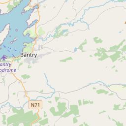

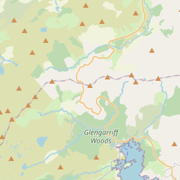

Leaflet | Map data © OpenStreetMap contributors
Achar
Bantry Urban has an area of 10.1 km² / 2,488.3 acres / 3.9 square miles.
Ceannbhailte
There are 22 townlands that we know about in . This represents 96.4% of all the area in .
- An Mhainistir 33 A, 1 R, 23 P
- Ard na Gaoithe Mór 212 A, 3 R, 27 P
- Cathair Dhonnaíle Thoir 116 A, 2 R, 34 P
- Cathair Dhonnaíle Thiar 113 A, 3 R, 25 P
- Ceapach na Luaithe Thoir 68 A, 2 R, 6 P
- Carraig na gCat 28 A, 1 R, 10 P
- An Chlais Dubh 27 A, 2 R, 13 P
- Dromleigh North 91 A, 0 R, 37 P
- Dromleigh South 399 A, 3 R, 19 P
- Lota an Mhuilinn 13 A, 1 R, 19 P
- Cill na Ruán 30 A, 3 R, 26 P
- Cionn Átha Fínín 9 A, 3 R, 26 P
- Cnoc na Muc 104 A, 3 R, 25 P
- Leathéadan 67 A, 2 R, 7 P
- Millín na Cuaillí 17 A, 3 R, 24 P
- An Baile Nua 336 A, 1 R, 27 P
- An Rinn Ramhar Thoir 21 A, 1 R, 24 P
- An Rinn Ramhar Thiar 86 A, 2 R, 3 P
- Gort na Mara 181 A, 1 R, 20 P
- An Seisceann 318 A, 1 R, 13 P
- An Stiall 24 A, 1 R, 27 P
- Town-lots 93 A, 0 R, 27 P
 OpenStreetMap
Bantry Urban was added to OpenStreetMap on 13 Ean 2017 by Teester.
- View
- Edit