Based on data in OpenStreetMap, here is a list of townlands in Lambeg (Down portion).
Lambeg (Down portion) is in the baronies of An Caisleán Riabhach.
Lambeg (Down portion) is in the counties of Contae an Dúin.
Lambeg (Down portion) is not matched up to Logainm.ie yet.
Léarscáil
It is located at 54° 31' 27" N, 6° 0' 32" W.
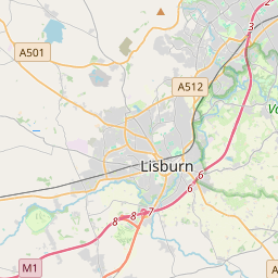
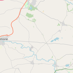

Leaflet | Map data © OpenStreetMap contributors
Achar
Lambeg (Down portion) has an area of 4.8 km² / 1,195.8 acres / 1.9 square miles.
Ceannbhailte
There are 3 townlands that we know about in Lambeg (Down portion). This represents 100% of all the area in Lambeg (Down portion).
- Ballyskeagh, Lambeg (Down portion) Paróiste Sibhialta, Barúntacht An Caisleán Riabhach, Co. Contae an Dúin 363 A, 3 R, 9 P
- Lisnatrunk, Lambeg (Down portion) Paróiste Sibhialta, Barúntacht An Caisleán Riabhach, Co. Contae an Dúin 295 A, 1 R, 24 P
- Tulaigh na Croise (Tulaigh na Croise) , Lambeg (Down portion) Paróiste Sibhialta, Barúntacht An Caisleán Riabhach, Co. Contae an Dúin 536 A, 2 R, 16 P
- Tulaigh na Croise (see Tulaigh na Croise (Tulaigh na Croise) , Lambeg (Down portion) Paróiste Sibhialta, Barúntacht An Caisleán Riabhach, Co. Contae an Dúin)
 OpenStreetMap
Lambeg (Down portion) was added to OpenStreetMap on 2 Lún 2016 by Stephen_Co_Antrim.
- View
- Edit