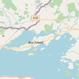
Based on data in OpenStreetMap, here is a list of townlands in the Electoral Division / ED / District Electoral Division of Kesh.
Kesh is in Co.
Kesh is not matched up to Logainm.ie yet.
Léarscáil
It is located at 54° 30' 29" N, 7° 43' 2" W.


Leaflet | Map data © OpenStreetMap contributors
Achar
Kesh has an area of 16.4 km² / 4,064.6 acres / 6.4 square miles.
Ceannbhailte
There are 37 townlands that we know about in . This represents 100% of all the area in .
- Aghama 45 A, 2 R, 39 P
- Agharainy 150 A, 3 R, 28 P
- Aghinver 164 A, 2 R, 1 P
- Ardatrave 54 A, 0 R, 22 P
- Ballynant 67 A, 3 R, 18 P
- Cady 145 A, 3 R, 32 P
- Camplany 100 A, 1 R, 13 P
- Clareview 213 A, 2 R, 26 P
- Cleenishmeen Island 36 A, 2 R, 26 P
- Cornacrea 52 A, 3 R, 14 P
- Creefin Island 2 A, 3 R, 29 P
- Crevinish 112 A, 0 R, 33 P
- Drumadraghy 141 A, 3 R, 20 P
- Drumard 214 A, 1 R, 33 P
- Drumbarna 136 A, 0 R, 32 P
- Drumcrin 75 A, 2 R, 34 P
- Drumhoney 169 A, 1 R, 38 P
- Drummoyagh 113 A, 0 R, 32 P
- Drumnacross 138 A, 3 R, 29 P
- Drumnarullagh 86 A, 0 R, 0 P
- Drumwhinny 143 A, 0 R, 13 P
- Fargrim 73 A, 0 R, 13 P
- Gorteen 81 A, 1 R, 30 P
- Gubbaroe 287 A, 1 R, 8 P
- Horse Island 4 A, 1 R, 16 P
- Killylea 48 A, 0 R, 21 P
- Kinnausy Island 9 A, 0 R, 24 P
- Lavaran 66 A, 3 R, 13 P
- Leaghan 101 A, 0 R, 35 P
- Lisingle 77 A, 0 R, 25 P
- Manoo 80 A, 0 R, 15 P
- Mantlin 161 A, 2 R, 4 P
- Mullanasaggart 82 A, 0 R, 19 P
- Rosscolban 345 A, 3 R, 5 P
- Tattykeel Lower 69 A, 2 R, 15 P
- Tullanaglug 94 A, 3 R, 13 P
- Tullycallrick 115 A, 1 R, 0 P
 OpenStreetMap
Kesh was added to OpenStreetMap on 13 Feabh 2021 by brianh.
- View
- Edit

 JOSM
JOSM iD
iD