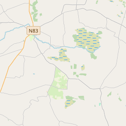
Based on data in OpenStreetMap, here is a list of townlands in the Electoral Division / ED / District Electoral Division of Hillsbrook.
Hillsbrook is in Co.
Hillsbrook is not matched up to Logainm.ie yet.
Léarscáil
It is located at 53° 29' 35" N, 8° 42' 34" W.


Leaflet | Map data © OpenStreetMap contributors
Achar
Hillsbrook has an area of 23.7 km² / 5,859.0 acres / 9.2 square miles.
Ceannbhailte
There are 26 townlands that we know about in . This represents 100% of all the area in .
- Barnaderg North 316 A, 1 R, 10 P
- Barnaderg South 221 A, 1 R, 0 P
- Cloonconra 232 A, 2 R, 3 P
- Cloondahamper (Blake) 470 A, 2 R, 39 P
- Cloondahamper (Brown) 203 A, 1 R, 13 P
- Cloonriddia 177 A, 2 R, 33 P
- Cooldorragha 181 A, 2 R, 36 P
- Cornacartan 212 A, 3 R, 16 P
- Corralea 215 A, 3 R, 0 P
- Corskeagh Beg 117 A, 3 R, 21 P
- Corskeagh More 252 A, 2 R, 30 P
- Cottage 136 A, 3 R, 4 P
- Derrybaun 175 A, 2 R, 30 P
- Fortyacres 74 A, 3 R, 33 P
- Hillsbrook Demense 406 A, 0 R, 15 P
- Knock 199 A, 2 R, 33 P
- Lisnaminaun 261 A, 1 R, 8 P
- Lissavally 187 A, 2 R, 1 P
- Lissavally Glebe 86 A, 0 R, 14 P
- Omaun Beg 316 A, 2 R, 18 P
- Omaun More 349 A, 2 R, 25 P
- Peak 131 A, 1 R, 30 P
- Pollacappul 216 A, 2 R, 31 P
- Stowelodge 261 A, 1 R, 31 P
- Tigreenaun 417 A, 0 R, 25 P
- Twentyacres 34 A, 3 R, 38 P
 OpenStreetMap
Hillsbrook was added to OpenStreetMap on 26 Samh 2016 by Boggedy.
- View
- Edit

 JOSM
JOSM iD
iD