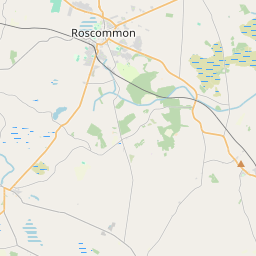
Based on data in OpenStreetMap, here is a list of townlands in the Electoral Division / ED / District Electoral Division of Cloonfinlough.
Cloonfinlough is in Co.
Cloonfinlough is not matched up to Logainm.ie yet.
Léarscáil
It is located at 53° 44' 23" N, 8° 8' 17" W.


Leaflet | Map data © OpenStreetMap contributors
Achar
Cloonfinlough has an area of 17.6 km² / 4,351.9 acres / 6.8 square miles.
Ceannbhailte
There are 24 townlands that we know about in . This represents 100% of all the area in .
- Ballinafad 275 A, 2 R, 1 P
- Ballintemple 113 A, 1 R, 16 P
- Cappagh 65 A, 0 R, 25 P
- Clare 192 A, 3 R, 35 P
- Cloonconny 89 A, 3 R, 6 P
- Cloonearagh 338 A, 3 R, 37 P
- Cloonelly 82 A, 2 R, 17 P
- Cloonerra 129 A, 2 R, 15 P
- Cluain Fionnlocha 412 A, 1 R, 2 P
- Cloonrane 305 A, 3 R, 18 P
- Coggalbeg 277 A, 3 R, 14 P
- Coggalfortyacres 167 A, 1 R, 36 P
- Coggalkeenagh 93 A, 2 R, 30 P
- Coggalmore 84 A, 2 R, 27 P
- Coggalstack 100 A, 3 R, 27 P
- Coggaltonroe 118 A, 1 R, 8 P
- Corboghil 141 A, 2 R, 38 P
- Curry 102 A, 3 R, 8 P
- Derreen 196 A, 2 R, 26 P
- Glennameeltoge 89 A, 2 R, 8 P
- Lisheenanierin 90 A, 2 R, 39 P
- Mothar 348 A, 3 R, 2 P
- Mountpleasant 254 A, 1 R, 17 P
- Oakfield 278 A, 0 R, 39 P
 OpenStreetMap
Cloonfinlough was added to OpenStreetMap on 25 Noll 2016 by Boggedy.
- View
- Edit

 JOSM
JOSM iD
iD