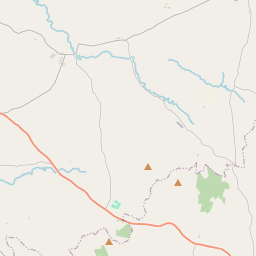
Based on data in OpenStreetMap, here is a list of townlands in the Electoral Division / ED / District Electoral Division of Augher.
Augher is in Co.
Augher is not matched up to Logainm.ie yet.
Léarscáil
It is located at 54° 25' 45" N, 7° 6' 52" W.


Leaflet | Map data © OpenStreetMap contributors
Achar
Augher has an area of 15.1 km² / 3,739.1 acres / 5.8 square miles.
Ceannbhailte
There are 21 townlands that we know about in . This represents 100% of all the area in .
- Alt na bhFiach 314 A, 3 R, 12 P
- Eanach Locháin 283 A, 1 R, 10 P
- Eochair 207 A, 1 R, 5 P
- Baile an Ghrianáin 194 A, 3 R, 17 P
- Baile an Lagáin 155 A, 0 R, 30 P
- Baile na gCurrach 196 A, 0 R, 3 P
- Bréntír 52 A, 1 R, 7 P
- Colldhroim 115 A, 1 R, 36 P
- Carr 206 A, 0 R, 15 P
- Castlehill Demesne 212 A, 2 R, 4 P
- Cor na Muclach 196 A, 2 R, 29 P
- Doiridhe 105 A, 3 R, 22 P
- Doire Cléithe 151 A, 3 R, 30 P
- Doire na Scuab 134 A, 1 R, 1 P
- Fearann Íochtrach 81 A, 3 R, 11 P
- Coill Chleithe 215 A, 1 R, 15 P
- Mullach mor 269 A, 2 R, 23 P
- Mulláin 141 A, 2 R, 12 P
- Ruadhchán 260 A, 3 R, 25 P
- Seiseadhach 93 A, 3 R, 30 P
- Tulaigh 149 A, 0 R, 26 P
 OpenStreetMap
Augher was added to OpenStreetMap on 2 Márta 2021 by b-unicycling.
- View
- Edit

 JOSM
JOSM iD
iD