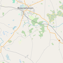
Based on data in OpenStreetMap, here is a list of townlands in the Electoral Division / ED / District Electoral Division of Mote.
Mote is in Co.
Mote is not matched up to Logainm.ie yet.
Map
It is located at 53° 35' 41" N, 8° 7' 22" W.


Leaflet | Map data © OpenStreetMap contributors
Area
Mote has an area of 32.7 km² / 8,082.9 acres / 12.6 square miles.
Townlands
There are 25 townlands that we know about in . This represents 97.2% of all the area in .
- Ballymurray 321 A, 0 R, 3 P
- Bogganfin 162 A, 3 R, 9 P
- Bolinree 126 A, 2 R, 31 P
- Carrowndrisha 470 A, 2 R, 16 P
- Cloonconra 220 A, 1 R, 34 P
- Clooncraff 805 A, 0 R, 23 P
- Cloonsellan 406 A, 2 R, 22 P
- Corgarve 131 A, 2 R, 15 P
- Cornamaddy 149 A, 3 R, 9 P
- Corroy 201 A, 1 R, 12 P
- Creggan 113 A, 3 R, 0 P
- Derrydonnell 236 A, 1 R, 13 P
- Galey 463 A, 1 R, 15 P
- Killea 57 A, 3 R, 10 P
- Killeenboy 589 A, 3 R, 8 P
- Laboge 61 A, 3 R, 10 P
- Lisnahoon 69 A, 3 R, 27 P
- Longnamuck 223 A, 2 R, 12 P
- Meehaun 74 A, 2 R, 11 P
- Moneymore 408 A, 0 R, 21 P
- Mote Demesne 1253 A, 2 R, 12 P
- Newtown 353 A, 1 R, 5 P
- Srah 87 A, 2 R, 32 P
- Tromaun 714 A, 3 R, 9 P
- Tullyroe 149 A, 3 R, 5 P
 OpenStreetMap
Mote was added to OpenStreetMap on 24 Dec 2016 by Boggedy.
- View
- Edit

 JOSM
JOSM iD
iD