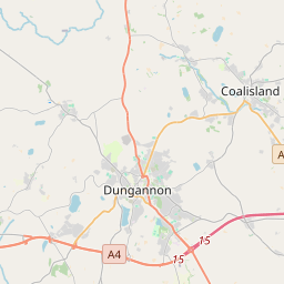
Based on data in OpenStreetMap, here is a list of townlands in the Electoral Division / ED / District Electoral Division of Derrygortrevy.
Derrygortrevy is in Co.
Derrygortrevy is not matched up to Logainm.ie yet.
Map
It is located at 54° 29' 4" N, 6° 47' 53" W.


Leaflet | Map data © OpenStreetMap contributors
Area
Derrygortrevy has an area of 19.8 km² / 4,900.3 acres / 7.7 square miles.
Townlands
There are 24 townlands that we know about in . This represents 100% of all the area in .
- Ballynorthland Demesne 125 A, 1 R, 21 P
- Ballysaggart 108 A, 1 R, 32 P
- Cormullagh 471 A, 3 R, 24 P
- Cottagequinn 284 A, 1 R, 17 P
- Derrygortrevy 251 A, 0 R, 13 P
- Derryveen 205 A, 1 R, 18 P
- Drumgormal 147 A, 3 R, 16 P
- Drumnashaloge 124 A, 0 R, 35 P
- Dunamony 346 A, 3 R, 21 P
- Eskragh 289 A, 2 R, 19 P
- Glenadush 239 A, 3 R, 35 P
- Gortmerron 134 A, 0 R, 35 P
- Killybracken 335 A, 0 R, 23 P
- Killymaddy (Knox) 339 A, 1 R, 16 P
- Killymeal 75 A, 1 R, 10 P
- Killyquinn 76 A, 3 R, 13 P
- Kilnacart 181 A, 1 R, 35 P
- Legilly 260 A, 2 R, 36 P
- Lisnahull 118 A, 1 R, 4 P
- Lissan 146 A, 1 R, 27 P
- Mulboy 173 A, 3 R, 0 P
- Mullaghadrolly 88 A, 2 R, 21 P
- Mullaghanagh 158 A, 1 R, 4 P
- Tyhan 216 A, 2 R, 35 P
 OpenStreetMap
Derrygortrevy was added to OpenStreetMap on 3 Mar 2021 by b-unicycling.
- View
- Edit

 JOSM
JOSM iD
iD