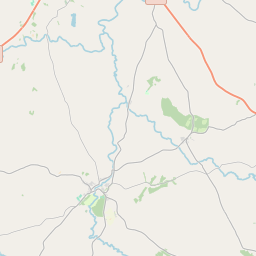
Based on data in OpenStreetMap, here is a list of townlands in the Electoral Division / ED / District Electoral Division of Kilfaddy.
Kilfaddy is in Co.
Kilfaddy is not matched up to Logainm.ie yet.
Map
It is located at 54° 27' 24" N, 7° 13' 42" W.


Leaflet | Map data © OpenStreetMap contributors
Area
Kilfaddy has an area of 28.2 km² / 6,958.3 acres / 10.9 square miles.
Townlands
There are 24 townlands that we know about in . This represents 100% of all the area in .
- Aghindrumman 159 A, 2 R, 24 P
- Altanaveragh 557 A, 2 R, 17 P
- Ballaghneed 407 A, 2 R, 24 P
- Carntall Beg 96 A, 3 R, 24 P
- Carntall More 162 A, 0 R, 8 P
- Cattor 188 A, 1 R, 12 P
- Corboe 682 A, 0 R, 8 P
- Corkhill 154 A, 0 R, 39 P
- Corkhill Demesne 88 A, 2 R, 34 P
- Dromore Lower 262 A, 2 R, 13 P
- Dromore Middle 409 A, 2 R, 19 P
- Dromore Upper 226 A, 1 R, 2 P
- Eskragh 534 A, 1 R, 24 P
- Fogart 238 A, 2 R, 37 P
- Killaney Lower 98 A, 3 R, 20 P
- Killaney Upper 53 A, 0 R, 2 P
- Killyfaddy 145 A, 3 R, 9 P
- Kilnahusogue 596 A, 1 R, 27 P
- Lislea 173 A, 0 R, 3 P
- Lurganaglare 324 A, 3 R, 32 P
- Mullans (Killyfaddy) 188 A, 2 R, 34 P
- Raveagh 237 A, 0 R, 33 P
- Skelgagh 224 A, 3 R, 9 P
- Tatnadaveny 746 A, 2 R, 22 P
 OpenStreetMap
Kilfaddy was added to OpenStreetMap on 4 Mar 2021 by b-unicycling.
- View
- Edit

 JOSM
JOSM iD
iD